top of page
THREADS OF GREEN
Stitching Together a Fragmented Community
In Teddy Cruz's VIS 101 course, the students were asked to observe an area of San Diego and critically analyze it to uncover its underlying issues. We were encouraged to use those observations to come up with creative, integrative solutions that positively transformed the city. For this project, I chose to observe the Mission Valley area, focusing mainly on Fashion Valley and the neighborhoods immediately surrounding it. I designed a series of connected, multi-use commercial parks within the community that served to stitch together the commercial/residential divide and create a greener, more walkable Mission Valley.

Stage 1: Surface Observation
I first began by simply observing the area using Google Earth and picking out areas that stood out to me. The screenshot that was the most interesting to me was this one of a beautiful pattern I found in the hillside neighborhood on the south side of Mission Valley.
I was interested in how the neighborhood fought the natural landscape around it to maintain its man-made suburban grid. Even though city construction attempted to flatten and divide the land, there were some areas where the mountain could not be manipulated, and suburbia was instead forced to adapt to the natural shape of the landscape.


Stage 2: Research
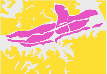
Next, I looked at the land use map and flood patterns of the area using the San Diego Government's interactive parcel map. I also researched how the invention of cars affected cities over the past century.

Land Use Map courtesy of SANDAG.
Pink = Commercial, Yellow/Brown = Residential,
Green = Natural

When rainy season hits San Diego, the river floods like crazy. This could be due to non-absorbent building materials used in city infrastructure.

The use of personal cars and the infrastructure needed to support their use led to the separation of modern cities.
Stage 3: Critical Analysis
I realized that there was a huge issue with freeways and parking lots. They are both examples of infrastructure that exists to serve cars, not people.
These structures take up valuable space that could be used for multiple possible purposes to enrich and invigorate a city, yet they sit and wait for machines to use them. They are also made from concrete, a material that doesn't absorb water at all. By fighting the landscape's texture, which usually would act as a natural drainage system, in the name of expansion these structures were exacerbating the valley's annual flooding problem. I concluded that these car-centric, single use pieces of infrastructure are the main source of Mission Valley's walkability and flooding issues.
Another issue I noticed from researching SANDAG's map was that if you squinted, the city was basically split up into a commercial and a residential area. The large central commercial space sort of acted like a wound in the fabric of the city.
This disruption in the city planning was also an accomplice to Mission Valley's walkability issue. Placing most of the commercial business in the center of town forces people to commute there.
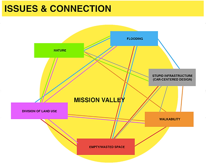
By the end of my research phase, I had identified 6 main issues and their possible causes. From my observations, I concluded that Mission Valley's poor city planning, wasted use of space on single use, car-centered infrastructure, and its fight against the natural landscape resulted in poor walkability and insane flooding during certain times of year.


Stage 4: Ideation
Imagining the commercial center as a wound or a tear in the residential fabric, I wondered how I might stitch the wound closed. Through brainstorming ideas in my head, I wondered what could happen if I actually used "stitches". I drew out this representation to follow my idea through.


As the stitches tightened, the wound was broken up into much smaller satellites. Spreading out the commercial real estate would allow people multiple different options for shopping. This would increase the walkability of the city, and even decrease car use, as most shopping centers would be within walking distance. I still wanted to find a way to include the natural landscape in my solution. It was then that I knew what I wanted to do...
Stage 5: My Solution


My solution incorporates human-centered and naturally inspired design to reorganize and de-homogenize the city with a network of social parks to reconnect Mission Valley community. These parks would exist in place of freeways, large concrete parking lots, and parts of existing neighborhoods, breaking up that mass of commercial land into many smaller, dispersed commercial islands. Dispersing the businesses would make accessing these centers much easier and reduce the need to use cars, as most would be within walking distance, or a short bus ride away.
The parks would be connected by longer, thinner stitches of green that serve as meandering walkways between parks, but also as a method of flood control. The paths within and between the parks would be made of a permeable surface, and rock gardens inspired by the native Kumeyaay rock drop methods would be displayed alongside these connecting paths to help control flood waters. These parks would act as social hubs, promoting communication and flow between communities as citizens would be drawn to them to get their shopping done as well as enjoy the beautiful grounds and other programs offered there.
Instead of the commercial land acting as a wound between residential communities, it would be transformed and dispersed to stitch them together -- healing the wound and actually promoting communication and flow within the city.


bottom of page